Drone Not Connected
 Make sure that the drone is powered up and the controller is linked to the drone (all LEDs on the remote should be green).
Mobile or tablet devices users:
Make sure that the USB cable is connected properly to the remote controller.
If your device asks you what app you would like to use after connecting the RC to the drone, make sure to select AgroScout Sky. (For more information: Troubleshoot Android connection issues )
If the above didn't work, try using a different cable.
If you're using the DJI RC Pro, please make sure to force stop DJI Fly
Drone Battery level


- Between 100%-51% battery level - ok to take-off ✔️
- Between 50%-31% battery level- battery is running low ⚠️ you can still take-off
- Under 30% - battery level is too low ❌ can't take off, please change the battery
SD Card error
Make sure you have a compatible Micro SD card and that it's inserted correctly into the SD card slot of the drone.
Note: inserting a MicroSD card into the remote controller is not needed.
We recommend always using a memory card, but If your drone has internal storage, you will be able to fly even without an SD card and the images will be saved to the internal storage.
Important note about memory cards:
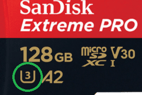
A UHS-I Speed Grade 3 rating microSD card is required.
Look for the U3 mark on the card to make sure it's compatible:

Make sure that the SD card is fully inserted into the SD card slot and go to the DJI app and set the storage location to SD card.
How to change the storage location to the SD card:
DJI GO 4 (Mavic 2 Pro and Phantom 4 Pro):
Open camera settings and set Storage Location to SD Card.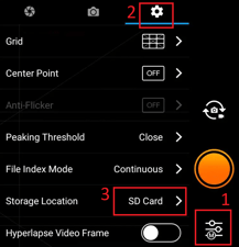
DJI Fly (Air 2S):
Open the settings, go to Camera and select SD Card.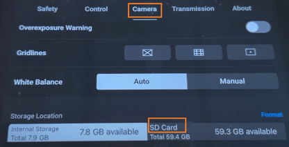

Not enough space on the SD card to store the images of this mission.
Free some space on this card and try again. To clear it all, format it using the DJI app.
Drone Calibration
The drone's compass needs calibration.
Click the "Fix it" Button next to the message.
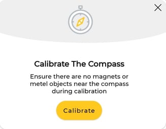
 Ensure there are no magnets or metal objects near the compass and click Calibrate
Follow the instructions and rotate the drone as shown
.jpeg?width=327&name=WhatsApp%20Image%202022-03-23%20at%2010.52.53%20(2).jpeg)
.jpeg?width=334&name=WhatsApp%20Image%202022-03-23%20at%2010.52.53%20(3).jpeg)
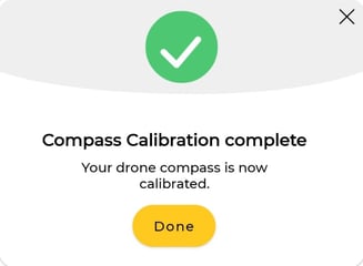
Click Done when finished.
Distance from polygon
 The take-off point is too far from the polygon, the maximum distance possible between the take-off and the polygon is 500 meters / 1600ft.
Change the polygon or set the take-off point closer.

Please see the "GPS Signal" fix below.
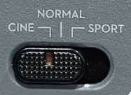
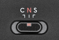
Flight Mode 'P':
Make sure the flight mode switch on the controller is set to P or N / Normal, and try again
GPS Signal
GPS signal is unavailable, please wait at least 1 minute from the drone start-up to let the GPS connects to satellites.
If the problem persists, power off the drone, find a new, open, clear spot for taking off, and then power it on and try again.